News / May 19, 2026
A Reveille Peak climb shows what is still visible after Tikaboo
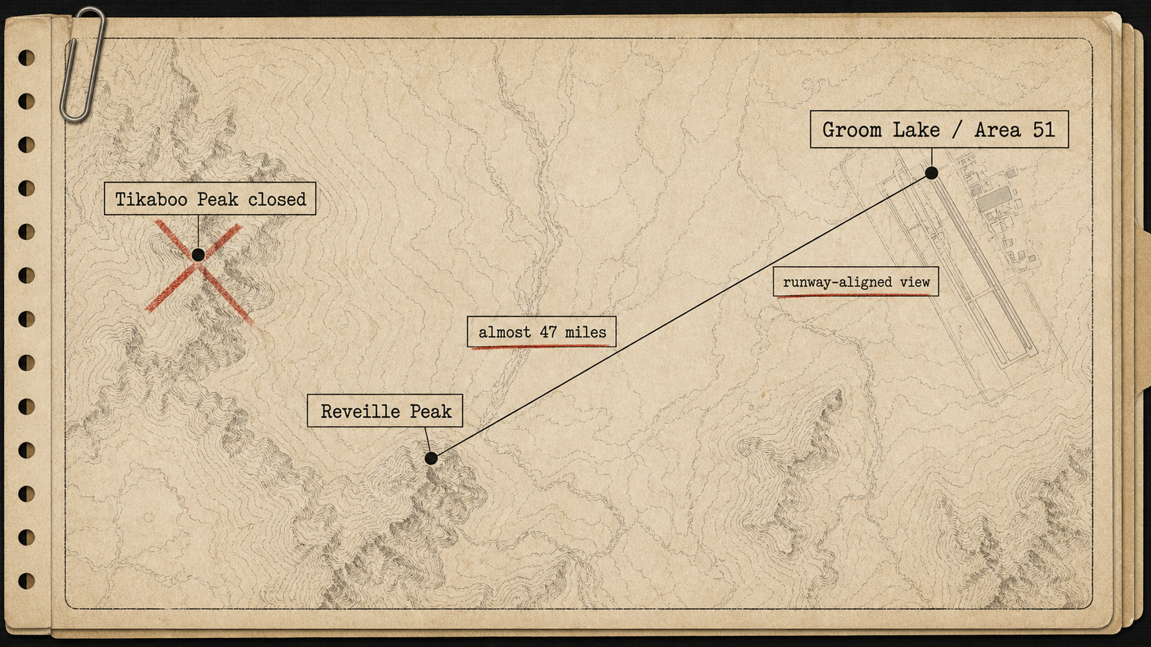
The climb does not make Reveille Peak the new Tikaboo. It shows the trade-off: a public line of sight, runway alignment, and almost 47 miles of desert in the way.
field sourceUncanny Expeditions: Reveille Peak climb
The field test
Uncanny Expeditions has posted a useful field test of Reveille Peak, the mountain now being discussed as the post-Tikaboo public viewpoint toward Area 51.
The video is not a new UAP case. It is more useful than that: a ground-level check of what can still be seen from public land after the Tikaboo Peak closure.
The short answer is: more than nothing, less than Tikaboo.
What the video is doing
The video starts with the March 2026 Badger Mountain / Tikaboo Peak closure and then moves to Reveille Peak as the remaining public alternative.
The creator frames the closure sharply, calling it a land seizure and accusing the government of using a safety justification to block observation of the base. That is his interpretation. The public document itself is narrower: the BLM closure order says the area is being closed because of steep slopes, unstable rocky ground, increased public use, remoteness, and rescue difficulty.
Both things can be true in the public debate: the official reason is safety, and Area 51 watchers see the practical result as the loss of a long-used public viewpoint.
For UAP Logbook, the useful part is not the outrage language. It is the climb.
Reveille is farther, but differently placed
In the video, the creator says Reveille Peak is almost 47 miles from Groom Lake. That is the key weakness.
Tikaboo Peak was already a long-lens viewpoint, not a casual overlook. Reveille pushes the distance problem further. Heat shimmer, haze, lens quality, and weather all matter more.
But Reveille has one possible advantage: orientation.
The video says Reveille sits on the northwest side of the test range and gives a view more directly down the runway. The creator argues that this makes some base structures appear from a different angle than they would from Tikaboo.
That is a practical point, not a mystery claim.
What was reportedly visible
From the summit, the video describes a surprisingly usable view of the base despite conditions that were not exceptionally clear.
The visible or claimed visible features include:
- the runway alignment;
- several hangars, including a 2007 hangar and what the creator identifies as Hangar 18;
- the rotating triangular tower and water tower;
- the RCS range;
- a truck moving perpendicular to the old runway;
- the 2014 hangar with its door facing the viewpoint;
- the control tower;
- the Papoose Mountain facility;
- a Janet flight arriving from Harry Reid International Airport.
That list is why the video matters. It suggests Reveille Peak is not just symbolic. It may still allow some public observation, especially of large structures and aircraft movement.
It also shows the limit.
The creator says night vision is not realistic at nearly 50 miles. He also says the Papoose Lake view is limited to the western edge, with the area many people care about obscured by terrain.
That is the sober part: Reveille preserves a line of sight, but it does not restore the Tikaboo-era viewing map.
The route context
The video also includes nearby Area 51-adjacent geography: Cedar Pipeline Ranch, a public marker for an F-117 crash site, and Cactus Gate, described as an overlooked entry point into the Nevada Test and Training Range.
Those are not central to the Reveille question, but they give the route context. This is not a clean tourist overlook. It is remote Nevada range country, with ranch roads, rough two-tracks, old crash markers, restricted boundaries, and a lot of distance between claims on a map and useful observation on the ground.
That context helps explain why Reveille Peak is a worse replacement and still worth documenting.
What this adds to the Tikaboo story
The Tikaboo closure changed a public-access map. Reveille Peak now tests what remains.
This video adds three useful points:
First, Reveille's runway-aligned angle may be genuinely interesting.
Second, distance is still the dominant fact. Almost 47 miles is not a replacement for Tikaboo's already-difficult view.
Third, the practical public-viewpoint story is now moving from "Where can you legally stand?" to "What can you still see from there?"
That is the right question.
What it does not prove
The video does not prove that the BLM's stated safety rationale is false.
It does not prove that Tikaboo was closed specifically to stop observation of Area 51.
It does not show UAP activity.
It does not turn Reveille Peak into the new Tikaboo.
What it does show is more modest and more useful: a public-land observer can still get a distant, runway-aligned view toward Groom Lake from Reveille Peak, with serious optical and terrain limits.
For now, that is the post-Tikaboo map.
Sources
- Uncanny Expeditions: "What AREA 51 Doesn't Want You To See | Climbing Reveille Peak After the Illegal Land Grab"
- BLM Temporary Closure Order, March 25, 2026
- BLM Closure Area Map
- The Aviationist: Tikaboo Peak, Legendary Area 51 Viewing Spot, Closed by U.S. Government
- UAP Logbook: What is Reveille Peak?