News / May 22, 2026
What is the Extraterrestrial Highway? Area 51 road explained
Nevada State Route 375 is marketed as the Extraterrestrial Highway. The road is real, Area 51 is nearby, and the useful story is where desert tourism, military secrecy, and UFO folklore overlap.
The short version
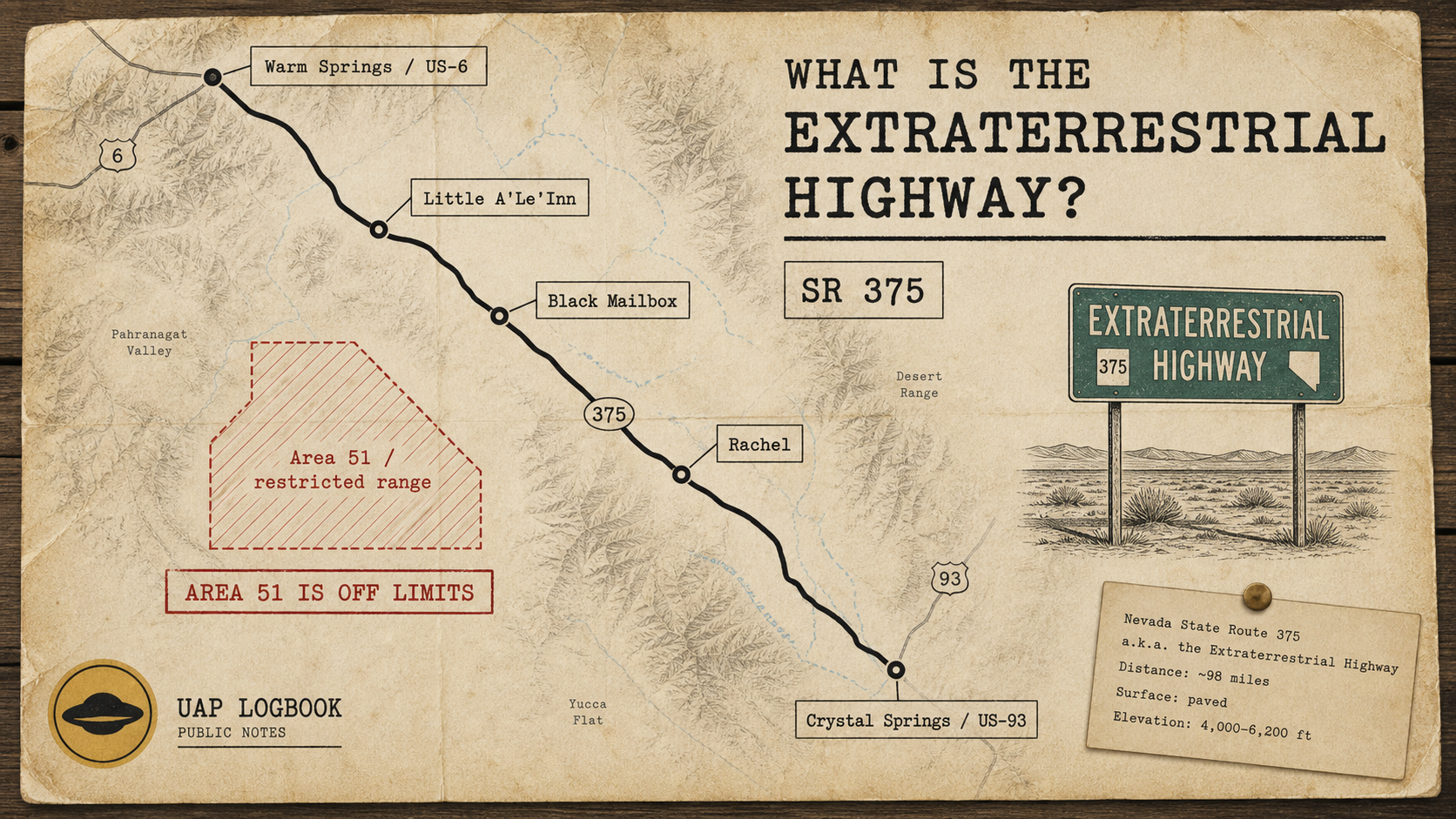
The Extraterrestrial Highway is Nevada State Route 375, a desert road running between the Crystal Springs area near U.S. 93 and Warm Springs near U.S. 6.
The road became famous because it passes through a landscape tied to Area 51 folklore: Rachel, the Little A'Le'Inn, the Black Mailbox, long empty stretches of desert, and roads leading toward restricted military land.
The useful point is simple: the highway is real, the tourism branding is real, and the nearby secrecy is real. That does not make the road evidence for UFO claims. It makes it one of the places where U.S. test-range secrecy and UFO culture visibly overlap.
The road
State Route 375 is a paved rural highway in south-central Nevada. It runs through a sparse basin-and-range landscape with long views, few services, and very little margin for casual mistakes.
Travel Nevada markets the route as the Extraterrestrial Highway and connects it to Rachel, the Little A'Le'Inn, the Alien Research Center, E.T. Fresh Jerky, and the wider Area 51 road-trip economy.
That marketing matters because it turned a road near restricted military geography into a public-facing myth route. People do not drive it only to get from one junction to another. They drive it because the map itself has become part of the story.
Why Area 51 is part of the story
Area 51 is the common name for the Groom Lake test facility inside the Nevada Test and Training Range area. It is not a tourist site. It is not open to visitors. It is not visible from the highway in any ordinary useful way.
What the highway gives visitors is proximity, not access.
That distinction is important. A road sign, a desert bar, a guarded dirt road, and a long view toward restricted land are not evidence of UAP activity. They are evidence of a cultural geography: public land at the edge of secret land, with decades of stories attached to the boundary.
Rachel and the Little A'Le'Inn
Rachel is the small settlement most strongly associated with the route. The Little A'Le'Inn functions as road-trip stop, souvenir site, local landmark, and informal Area 51 culture node.
That makes it useful for understanding the highway. It is where the official road meets the informal archive: photographs, stories, visitors, local warnings, jokes, speculation, and the practical reality of being far from almost everything.
For a UAP article, Rachel should not be treated as a claim source by itself. It is context. It shows how the Area 51 story moved from classified aviation and guarded desert roads into tourism, signs, T-shirts, diners, YouTube videos, and search traffic.
The Black Mailbox
The Black Mailbox is another landmark in the route's folklore. It has been treated by visitors as a meeting point, photo stop, and symbolic edge marker for Area 51 stories.
The name is more powerful than the object. The mailbox does not prove anything about UFOs. It shows how a plain roadside object can become a waypoint once enough people attach a story to it.
That is why it belongs in the article, but only as folklore geography. The useful question is not what the mailbox "means." The useful question is how ordinary landmarks become part of a shared map around secrecy.
What the Sidetrack Adventures video adds
A recent Sidetrack Adventures video is useful because it shows the route as a road, not just as a legend.
The video moves through Crystal Springs, route history, Hancock Summit, the Black Mailbox, Coyote Summit, Back Gate Road, Rachel, Twin Springs, and Warm Springs. It is not a disclosure video and does not present new UAP evidence. Its value is visual context: distance, emptiness, road conditions, signage, and the way the landscape carries the mythology.
For UAP Logbook, that is enough. Sometimes the useful article is not about a new claim. It is about the map people keep using when they talk about the claim.
What can actually be checked
- State Route 375 exists and is publicly drivable under ordinary road conditions.
- Rachel and the Little A'Le'Inn are real stops on the route.
- The road sits near the broader geography associated with Area 51 and the Nevada Test and Training Range.
- Restricted land remains restricted. Public road access is not permission to enter closed military areas.
- Most UFO value here is cultural and historical, not evidentiary.
Why it matters anyway
The Extraterrestrial Highway matters because it is one of the clearest examples of how UAP culture attaches itself to real places.
The road does not need to prove aliens to be worth documenting. It connects official secrecy, aviation history, desert tourism, local business, internet folklore, and the public desire to stand as close as legally possible to a place they are not allowed to enter.
That is why it fits UAP Logbook. It is not a case file. It is infrastructure for the myth.